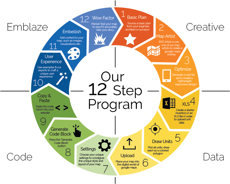
1. Basic Plan – Start out with any map, it can be an illustrator file, engineering or architectural AutoCAD drawings. Use this as your map building platform. This starter map can be super basic, as you will be working over top of it and using it to keep the map scaling accurate.
2. Map Artist – Select a Map Artist, either hire your own or we can provide an artist for you; we recommend a designer with AutoCad and cartography experience. This Map Artist will create a stylized tile set of map overlays for google maps, to suit the look and feel of your product or service.
3. Optimize – Whether we create your map overlays, or receive them from your designer, we will optimize them for perfect universal viewing over the web on any device using tiling and other techniques, to ensure a robust experience.
4. XLS – Create a starter inventory of each lot, apartment or unit and all the necessary information will need to be created and uploaded. We can then plug in to your unit database, then update and add information dynamically once the initial inventory has been created.
5. Draw Units – Each area of interest, whether it be a local amenity, a lot or apartment, is represented on MapsPLUS as a colored outline called a polygon. These polygons are colored to represent sales status or any other state that you care to represent on your map.
6. Upload – We will now take your map overlay or overlays, and upload and positioned them in google maps, to allow people to fully understand the location of your real-estate project in terms of the incredible content google maps has to offer, such as streetview, photos and videos.
7. Settings – Choose the unique configuration of your starter map, so that attributes of the style, positioning and user experience can be set-up to reflect your unique vision.
8. Generate Code Block – Simply, at the press of a button, download the block of code that will be used as the starter code for your map.
9. Copy & Paste – Copy your code block and paste it in the desired location on your website. That code will call the map, to be rendered from our servers, onto your page quickly and reliably.
10. User Experience – (Optional) Taking the starter code, you can craft an experience that is engaging and really tells the unique story of your real-estate project. We have user experience experts on staff to help you and your team with this.
11. Embellish – (Optional) All the possibilities in the world are open to visually tell your real-estate story, everything from 3D tours, drone flights, visualizations, video, etc.
12. Wow Factor – (Optional) Market test your map to see if your map accurately tells your story. You can always come back using your analytics to find ways to optimize the user experience and maximize it’s conversion capability.